
The polder landscape around Delft is not flat. On the contrary, some areas are several meters lower than others. This was/is caused by local variations in land subsidence and peat extraction. Therefore, sub-polders had to be created. The Polder of Nootdorp, for example, consists of more than 15 sub-polders, each with its own flood protection and channels and ditches. Each sub-polder has its own target water level, as you can see on this map.
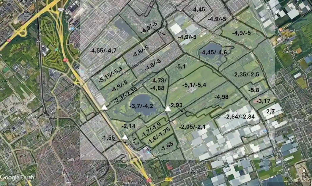
Polder levels along the Outer Delft Water Walk – see also map below with levels within the Binnenboezem.
Water flows from high to low. This creates a cascade of waterways, in which water flows from higher-lying sub-polders to lower ones. Within these sub-polders, many drainage ditches have been constructed over the centuries. This is clearly visible on historical maps, such as the Cruquius Map from 1712. The landscape pattern from that period is still recognizable in our polder landscape.
Before we elaborate further on this cascade of waterways, we must first delve into the ground. Around Delft, the soil consists of clay and peat. This soil type has a very low permeability. This means that water has difficulty flowing through the soil, as we explain in “What is groundwater?“. In fact, water can travel less than 0.01 mm per day here, as you can read in this Wikipedia article. So, after a downpour, rainwater does not flow through the soil to the ditches in and around the polder. The water balance in the meadow-peat landscapes, such as those around Delft, is therefore determined by the difference between precipitation and evaporation. That is why many meadows are wet almost throughout the winter.
But if there is too much water on the meadows, it can, of course, flow over the grass surface into the polder’s ditches and canals. This happens even faster if the soil is hardened by paving or constructions. Then, a lot of water can suddenly accumulate in the ditches and canals. All that water cascades down through the canals and ditches into the deepest sub-polder. From there, it must be pumped out towards the Boezem (primary drainage canal) to prevent flooding.
In the summer, if it does not rain for many weeks or even months, the polder can also become too dry. This causes problems for nature, water quality, and sometimes even for local businesses, as explained below. In such cases, the polder’s water system can be used to replenish water in a controlled manner, thus refreshing the water in the canals and ditches. Another problem with enduring draughts is the drying gout of peat dikes. These can then become unstable and slide away. Here you read about a scientific analysis of an “almost disaster” in 2003 when a peat dike near Wilnis became unstable.
Thus, a tiered, hierarchical system was designed to allow water to be admitted, discharged, and circulated. At the top of the hierarchy is the Boezem (primary drainage channel). The Boezem can discharge water into the Binnenboezem (secondary drainage channel). The Binnenboezem runs along the polders and then transports water to the wetering (the main watercourse within a polder) and from there to the polder ditches. If it is too wet, water from the polder is pumped into the Boezem. If there is too little, water from either the Boezem or Binnenboezem is admitted into the polder. Sometimes water in a binnenboezem can flow in both directions, such as in the Bieslandse Molensloot (Bieslandse Molensloot). This system is also used to circulate water in the polders, maintaining water quality, including salinity. The satellite image below shows the Boezem and Binnenboezem in the polders of our Water Walk.
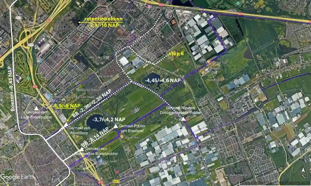
Boezem, Binnenboezem (BB), pumping stations (white triangles), and polder borders (blue line, see also “Polders Overview“) along the cycle route. The northern Binnenboezem (-2.3/-2.35 m NAP) is the Tweemolentjesvaart canal, and the southern one (-2.14 m NAP) is the Bieslandse Molensloot canal.
The meadow-peat landscapes in the polders area are very susceptible to compaction, which can cause significant land subsidence (see Oude Delftse Waterloop – Land Subsidence). Drainage in particular is a major culprit. This is how the polders were formed. Furthermore, large quantities of peat have been extracted at various locations. To minimize this drainage, the water level in the polders is kept as high as possible. Naturally, this accounts for the land’s use, such as housing, business, and agriculture. This water level is set in the Water Level Decree (Peilbesluit) of the Delfland Water Board; this sets the target water level in the Boezem, de Binnenboezem and the polder. In summer, the target water level is often higher than in winter. The higher summer water level compensates for evaporation, which is higher in summer than in winter. The lower winter water level provides a buffer to absorb precipitation during the wet winter months.
There are two binnenboezems in our area: the Tweemolentjesvaart / Nootdorpse Plassen with a target water level of -2.3/-2.35 m NAP (summer/winter level) and the Bieslandse Molensloot (parallel to the Korftlaan) with a target water level of -2.14 m NAP.
The Tweemolentjesvaart Binnenboezem begins at the lock in Tweemolentjeskade / Aan ‘t Verlaat (stop 2) and splits immediately after the Nootdorp pumping station (stop 3) into two parallel waterways: the Tweemolentjesvaart and the Nootdorpse Plassen. This binnenboezem branches off towards Delfgauw and continues towards Nootdorp, almost reaching the A12 motorway. The total length of this Binnenboezem is over 7 km.
The Bieslandse Molensloot Binnenboezem begins at the Bieslandse Bovenpolder pumping station and runs to the Bieslandse Polder pumping station. This binnenboezem is approximately 1 km long.
Surrounding these binnenboezems are the three polders: the Bieslandse Bovenpolder, the Biesland Polder, and the Nootdorp Polder. As explained, the target water level within these polders is not constant – there is a wide variation in polder levels, as shown on the map above. You can read all these levels yourself on the so-called leggerkaarten (water reference maps) of the Delfland Water Board.
The map shows how the Bieslandse Molenvaart (-2.14 m NAP) regulates the water level in part of the Bieslandse Bovenpolder. The polder level in the part of the Bieslandse Polder, where you find the Bieslandhoeve, is regulated by this Binnenboezem, together with the Biesland Polder pumping station.
Other parts of the Bieslandse Bovenpolder and Bieslandse Polder, including the Grote Plas, are connected to the Tweemolentjesvaart by overflows.
This is how the water flows through the polder, from one sub-polder to another, lower-lying sub-polder. Gradually, via overflows, the water flows into increasingly deeper ditches, as we will see during our Water Walk. North of the Nootdorp Polder Pumping Station, we find the deepest sub-polder. The target water level here is even -4.9 m NAP in summer and -5 m NAP in winter. From there, the pumping station pumps the polder water back into the Boezem. The water’s residence time in the Boezem is approximately 30 to 40 days. However, it takes much longer for water to circulate through the entire polder system, especially during dry periods. The following more detailed map shows where water is pumped from the deepest sub-polder into the Boezem and where water flows from the Boezem to the Binnenboezem.
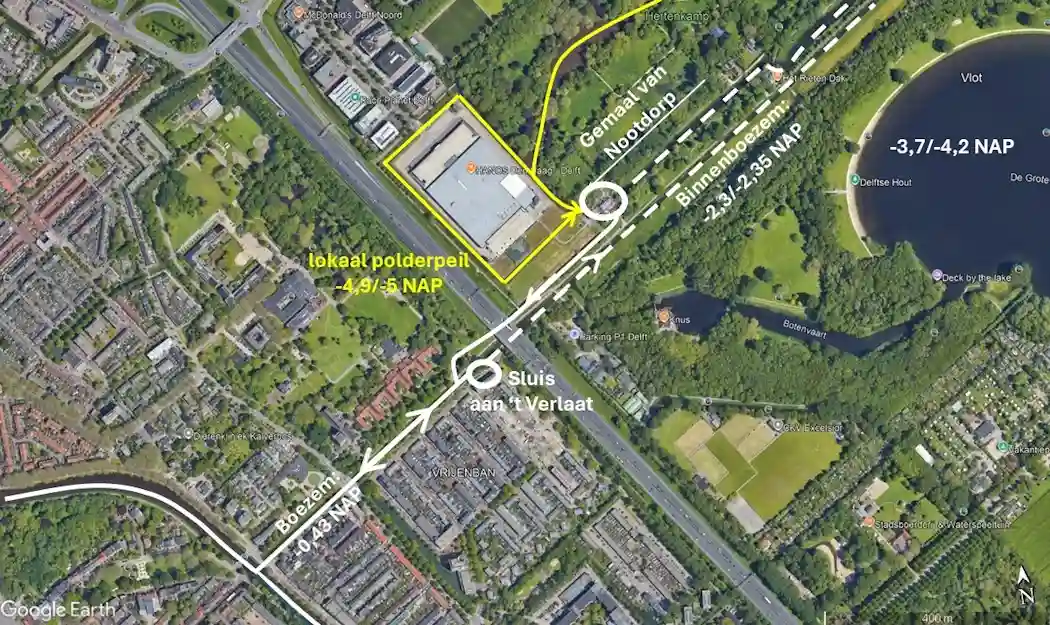
Target levels and water circulation around the Nootdorp Polder pumping station.